USGS Station 09379500 • Lat 37.1507°, Long -109.8667° • Elevation Utah Basin
Flow is in the upper quartile (above 75th percentile) or flood stage. Powerful hydraulics and washed-out features may be present. Assess in person.
Flow is significantly elevated. Wading can be hazardous at higher percentiles, and water may be off-color. Always assess in person.
Conditions change quickly. Always verify locally and use your own judgment before entering any body of water. This data is informational only and provided as-is.
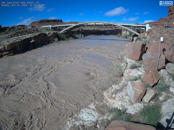
San Juan River near Bluff, UT
View High-Res PhotoPins show this gauge (highlighted) and up to 5 nearby USGS stations. Tap any pin or use the list to check conditions upstream or downstream.
Colorado River at Lees Ferry, AZ
USGS Station 09380000 • 97.0047121004012 mi away
Animas River at Durango, CO
USGS Station 09361500 • 109.652891862658 mi away
Colorado River near Cisco, UT
USGS Station 09180500 • 118.857144893993 mi away
Little Colorado River near Cameron, AZ
USGS Station 09402000 • 126.760327637494 mi away
Green River near Green River, UT
USGS Station 09315000 • 127.941816639982 mi away
Guide or outfit trips near San Juan River near Bluff, UT?
Connect directly with river runners checking water levels on station #09379500.
Verified answers based on USGS station #09379500 live telemetry and historical statistics.
The current water level (stage height) at San Juan River near Bluff, UT (USGS #09379500) is 9.46 ft with a streamflow discharge of 4,470 CFS. Real-time condition is rated High (well above average for this specific day of the year) and stream levels are rising.
Normal seasonal flow for San Juan River near Bluff, UT is determined from decades of USGS daily-mean discharge percentiles. Flow between the 10th percentile (541 CFS) and 75th percentile (1,785 CFS) is classified as Normal, with the historical daily mean flow being 800 CFS for this date.
The official National Weather Service (NWS) flood stage for USGS #09379500 is 11 feet. With current water level at 9.46 ft, this station is currently below flood stage (margin of 1.5 ft).
USGS gauge #09379500 (San Juan River near Bluff, UT) is located at latitude 37.1507°, longitude -109.8667° in Utah. Data is transmitted via USGS GOES satellite telemetry every 15 to 60 minutes and refreshed automatically on ClearGauge every 15 minutes.
Current flow is rated High. Flow is in the upper quartile or approaching flood stage. Expect powerful hydraulics, reduced eddy lines, cold runoff, and submerged hazards. Always inspect rapids in person, wear a USCG-approved PFD, and check weather alerts before launching.
National Water Information System (NWIS) • Automated satellite telemetry transmission every 15 to 60 minutes.
Live readings via USGS satellite telemetry, updated every 15–60 minutes. Low / Normal / High verdicts are based on the 10th and 75th percentile discharge thresholds from the USGS Daily Statistics Service (decades of approved daily-mean data). Flood Risk uses the NWS published flood stage where available. Full methodology →
River Safety Notice
River conditions can change abruptly due to upstream reservoir releases, sudden mountain thunderstorms, flash flooding, and seasonal snowmelt surges. Always scout rapids prior to commitment, wear an approved USCG Type III/V Personal Flotation Device (PFD), carry appropriate rescue gear, and check local emergency management bulletins before launching.
