USGS Station 15516000 • Lat 63.4573°, Long -148.8054° • Elevation Alaska Basin
Flow is in the upper quartile (above 75th percentile) or flood stage. Powerful hydraulics and washed-out features may be present. Assess in person.
Flow is significantly elevated. Wading can be hazardous at higher percentiles, and water may be off-color. Always assess in person.
Conditions change quickly. Always verify locally and use your own judgment before entering any body of water. This data is informational only and provided as-is.
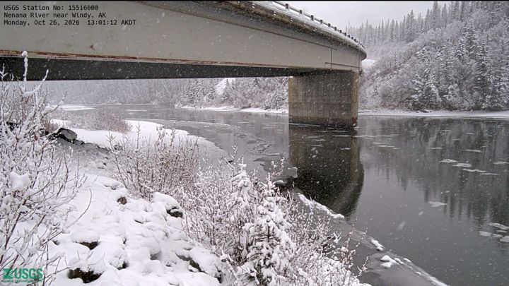
Parks Highway Bridge 1243 over the Nenana River near Windy, north of Cantwell, AK. View looking downstream at Pier 2 from the upstream left bank.
View High-Res PhotoPins show this gauge (highlighted) and up to 5 nearby USGS stations. Tap any pin or use the list to check conditions upstream or downstream.
Kenai River at Cooper Landing, AK
USGS Station 15258000 • 207.442397787852 mi away
Stehekin River at Stehekin, WA
USGS Station 12451000 • 1486.86167459896 mi away
Skykomish River near Gold Bar, WA
USGS Station 12134500 • 1489.53485614285 mi away
Green River near Auburn, WA
USGS Station 12113000 • 1506.21463921575 mi away
Chehalis River near Grand Mound, WA
USGS Station 12027500 • 1516.93547220739 mi away
Guide or outfit trips near Nenana River near Windy, AK?
Connect directly with river runners checking water levels on station #15516000.
Verified answers based on USGS station #15516000 live telemetry and historical statistics.
The current water level (stage height) at Nenana River near Windy, AK (USGS #15516000) is 2003.19 ft. Real-time condition is rated Flood Risk (at current levels) and stream levels are unknown.
Normal seasonal flow for Nenana River near Windy, AK is determined from decades of USGS daily-mean discharge percentiles. Flow between the 10th percentile (244 CFS) and 75th percentile (555 CFS) is classified as Normal.
The official National Weather Service (NWS) flood stage for USGS #15516000 is 16 feet. With current water level at 2003.19 ft, this station is currently at or above FLOOD STAGE. Take extreme caution.
USGS gauge #15516000 (Nenana River near Windy, AK) is located at latitude 63.4573°, longitude -148.8054° in Alaska. Data is transmitted via USGS GOES satellite telemetry every 15 to 60 minutes and refreshed automatically on ClearGauge every 15 minutes.
Current flow is rated Flood Risk. DANGEROUS FLOOD STAGE: Water velocities are hazardous, debris may be in transit, and boat ramps/access points may be submerged. Avoid on-water recreation. Always inspect rapids in person, wear a USCG-approved PFD, and check weather alerts before launching.
National Water Information System (NWIS) • Automated satellite telemetry transmission every 15 to 60 minutes.
Live readings via USGS satellite telemetry, updated every 15–60 minutes. Low / Normal / High verdicts are based on the 10th and 75th percentile discharge thresholds from the USGS Daily Statistics Service (decades of approved daily-mean data). Flood Risk uses the NWS published flood stage where available. Full methodology →
River Safety Notice
River conditions can change abruptly due to upstream reservoir releases, sudden mountain thunderstorms, flash flooding, and seasonal snowmelt surges. Always scout rapids prior to commitment, wear an approved USCG Type III/V Personal Flotation Device (PFD), carry appropriate rescue gear, and check local emergency management bulletins before launching.
